Explore Delhi’s most iconic radial-planned zones in this DWG map. Learn how to interpret and recreate built-up density maps using AutoCAD for urban design, planning, or thesis work.
🧭 1. What This Drawing Depicts
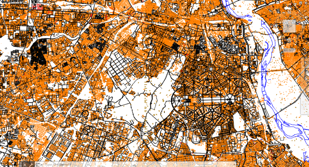
This is a city-scale planning map focused on central Delhi, revealing:
- 🧱 Built-up zones (highlighted in orange)
- 🛣️ Lutyens’ road network with radial symmetry (Connaught Place, Rajpath, India Gate axis)
- 🌊 Yamuna River geometry (plotted in blue)
- 🟧 Institutional/Monumental land uses
- 🔲 Open spaces, parks, and undeveloped land
- 🔍 Parcel-level detail visible even at micro zoom levels
This drawing can act as a base map, urban morphology study, or a layer in a GIS-CAD hybrid project.
🎓 2. Who Can Use This?
✅ M.Plan Students – Urban morphology, density analysis
✅ GIS + CAD Learners – Overlay real satellite data on it
✅ Urban Design Studios – Use as base for reimagination projects
✅ Heritage & Policy Researchers – Analyze built-vs-open ratios
🛠️ 3. How to Recreate or Use This in AutoCAD
- Understanding the Layers
| Layer Name | Description | Color |
| Built_Up | Plotted buildings (orange solid fill) | Orange |
| Roads | All vehicular and pedestrian paths | Black |
| Water_Bodies | Rivers, lakes, canals | Blue |
| Parks_OpenSpace | Green zones, gardens | White/None |
- Steps to Build Something Similar
- Import Base Map
- Use Insert > Raster Image to overlay a satellite view
- Trace major roads using PLINE
- Draw plots/buildings manually using RECTANG, PLINE, OFFSET
- Apply Hatch Patterns
- Use HATCH to fill buildings with solid orange
- Open spaces can be hatched with gradient or dotted fill
- Label with MTEXT
- Add zone codes, road names, or population density later
- Create Grid Overlays (Optional)
- Use ARRAY or DIVIDE for spatial indexing
💡 4. What You Learn From This Drawing
- 🧭 Classic urban geometry from Lutyens’ Delhi
- 🧮 Density distribution in historic city centers
- 📏 Parcel-level built form comprehension
- 🌍 GIS-ready file structuring for urban analysis
📥 5. Download the File

🔗 [Click to Download Delhi Urban Form DWG]